.
The images below show the Fort Calhoun nuclear power plant north of Omaha Nebraska, surrounded by Missouri River floodwaters (click each photo for larger versions). The first photo was taken by the Army Corps of Engineers on 16 June 2011. The river is still rising. The Cooper nuclear power plant farther downstream is also threatened.


Administration Building

The reactor building is being protected by water-filled berm-bags.

Hopefully the river won’t rise over the berms and cause it to get “all Fukushimaed”.
It is important to note that the Fort Calhoun plant is currently in so-called "cold" shutdown. It is however still fueled, and both the reactor core and the spent fuel pool require continuous cooling to avoid melting. The Cooper plant is currently operating, but a shutdown is planned if the river continues to rise.
Fort Calhoun had an electrical fire on 7 June that caused the cooling of the spent fuel pool to be interrupted for 90 minutes. The workers were able to restore power before it began to boil. While the official story is that and that the temperature rise was only 2 degrees over the 90 minutes, and it would take “88 hours for the heat produced by the spent fuel to boil away the cooling water”, fuel damage, hydrogen generation, and radiation release would occur long before all the water was gone.
Officials are mum on what caused the fire. Most folks are speculating that it was the flooding that caused it.
Additional diesel generators have been brought on site, the Nuclear Regulatory Commission has a team there, and about 60 extra employees are sleeping on cots, ready for duty in case of any further “anomalies”.
Snow runoff is 140% of normal – caused by a very cold spring in the entire western part of the US (consistent with the continuing global cooling over the last decade). Precipitation that would have normally fallen as rain throughout April and May fell as snow in the Rocky Mountains. Now it is melting and moving downstream. This, on top of normal early summer thunderstorms, is causing unprecedented flooding in the Dakotas, and now in Nebraska.
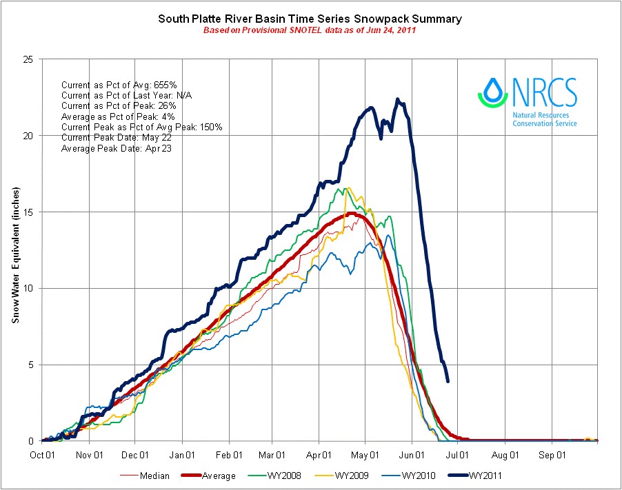
Note that the snowfall was higher than the average (red line) into April, but then instead of beginning the melt season in late April, more snow fell for an additional month -- more snow than in living memory. In an average year, without global cooling, this precipitation would have been rain. The South Platte basin is shown above, but the pattern was repeated throughout the mountains of the western US.
Oddly, Russian and Pakistani media are reporting that the IAEA told the Russians that the Obama administration has instituted a news blackout about what “really happened” to the spent fuel pool during the fire… But who trusts Russia and Pakistan? I suspect there may have been a minor radiation release.
How bad could the situation get? If the peak flood stays below the berms, all will likely be OK, but the real concern is upstream dam integrity in South Dakota and even Montana. If one of those six upper Missouri dams goes, the domino effect would overtop downstream dams, quickly wash them away, and both nuclear plants would be gone. The dams are all full to the brim. They have been described as "six old, huge, faulty dams", some with floodgates that, until now, had not been opened in between 30 and 50 years.
From St. Louis Today:
The Fort Peck Dam is built with a flawed design that has suffered a well-known fate for this type of dam — liquefaction — in which saturated soil loses its stability. Hydraulic-fill dams are prone to almost instant collapse from stress or earthquakes. California required all hydraulic-fill dams be torn out or rebuilt — and no other large dams have been built this way since.
At three miles wide, Fort Peck Dam last opened its floodgates 36 years ago. By the end of the first week in June, the U.S. Army Corps of Engineers will be releasing a record spill of water. The corps recently answered the question of possible failure with a statement the dam is "absolutely safe." It may be the largest at-risk dam in the nation.
Downstream, Garrison Dam never has had to use its floodgates since the dam was constructed 50 years ago. By mid-June, the corps plans to dump water equal to a good-sized river. The same is true for Oahe Dam, the next one downstream. Since the reservoirs are nearly full, the corps has no choice.
Effective flood control from six large dams is no longer an option. As a corps representative said, "It now moves us into uncharted territory."
We must all pose a question of national significance to the corps: What if Fort Peck Dam should fail?
Here is a likely scenario: Garrison, Oahe and three other downstream earthen dams would have to catch and hold a massive amount of water, an area covering nearly 250 square miles 100 feet deep. But earthen dams, when overtopped with floodwater, do not stand. They break and erode away, usually within an hour. All are full.
There is a possibility a failure of Fort Peck Dam could lead to a domino-like collapse of all five downstream dams. It probably would wreck every bridge, highway, pipeline and power line and split the heartland of the nation, leaving a gap 1,500 miles wide. Countless sewage treatment plants, toxic waste sites and even Superfund sites would be flushed downstream. The death toll and blow to our economy would be ghastly.

Dams on the upper Missouri River
Here are some more photos of the flooding:

Omaha Skyline and Interstate 29

Farm house

Interstate 29 north of Omaha
This could be another wild ride. You may want to check out this prior post of mine on medical protection against radiation: http://bigdustup.blogspot.com/2011/03/everything-you-ever-need-to-know-about.html
.
No comments:
Post a Comment